Adopted from my 2005-2006
"The Future South Capitol Street Gateway" web site
 illustration from The Washington Post January 17, 2004, with East Capitol Street foreground and South Capitol Street at top edge
media "reporting" replete with vagueness and omission
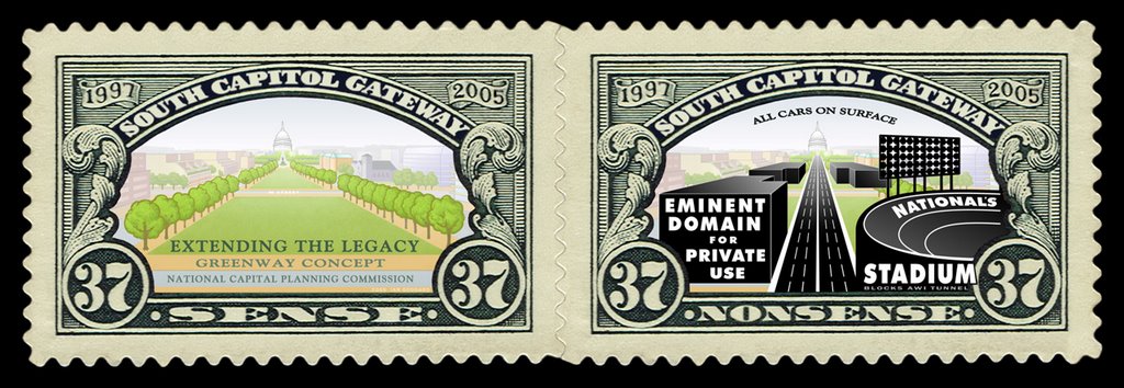
Examples of this include articles in The Washington Post (750+ thousand daily- largest in the U.S. Capital City) by staff writer Benjamin Forgery, including one datedJanuary 17, 2004 about the exhibit at the National Building Museum " D.C. Builds: The Anacostia Waterfront" with the illustration at right with East Capitol Street in the foreground, and with South Capitol Street at the top edge where it can barely be seen. The time is right. Washington, it seems, is due a great plan every century or so -- L' Enfant's in 1791, the McMillan Commission's in 1901, and now . . . hmm, I'm not ready quite yet to anoint the Anacostia plan to such elevated status. But, together with "Extending the Legacy," the federal government's enlightened 1997 plan, the city's contribution has rich possibilities."...together with "Extending the Legacy... the city's contribution has rich possibilities" Both include massive real estate redevelopment, with the Legacy plan featuring a 250' wide linear green way along the South Capitol axis that tapers becoming narrower as it extends north, and the "city's contribution" (the November 2003 AWI report) one only 22' wide, or 22' or 12' wide depending on which option was selected from the November 2003 ULI Advisory Services Report: these later options to conform with the decision to keep South Capitol Street with its existing 130' width (+15' per side for wider sidewalks), reportedly to save existing buildings from being demolished. So which is it?
To experience them firsthand, that great model at the Building Museum is the place to begin. Laser-cut with the benefit of the latest Geographic Information System data, it is an awesomely detailed stimulant to the imagination.
That model shows the future South Capitol Street without the 1997 Legacy plan's broad South Capitol green way to fit within its existing 130' (or 160') total right of way, in order to save existing buildings that get nonetheless replaced by new real estate redevelopment: a rejection of eminent domain for public use; and an embracing of eminent domain for private use. So why no mention of any of this in the article's text?Or his Monday, July 12, 2004 article (1st in a 5 part series; Page C01) "The Ripple Effect: An $8 Billion Development Plan Promises Payoffs Far Beyond the High-Water Mark" coming no closer to reporting on this plan substitution then stating:
The two plans are in basic agreement. Both call for new, mixed-use neighborhoods in the city's eastern segments. Both emphasize mass transit and new transportation infrastructure. Both advocate an active, urbane Anacostia waterfront. The Legacy plan foresees spreading the cultural wealth of memorials and museums beyond Washington's monumental core. The Anacostia planners rightfully embraced this inspired idea in proposals for major parks on both sides of the river at either end of the South Capitol Street Bridge.
"...in basic agreement" as if there were no disagreements worth even mentioning?!
failing to question the justification to avoid displacing existing buildings, in the context where the building are nonetheless removed and replaced by new real estate development
 Page 1, The Southwester, July 2003
 Page 5, The Southwester, July 2003
The Southwester (JULY 2003) circulation 10,000, gets it right in reporting on the decision to keep South Capitol Street at 130 feet, and it is accompanied by the correct (subsequent) illustrations, clearly showing South Capitol Street with a median "green way" no wider then 12'.But it repeats the study's point that "Creating the South Capitol Street Gateway appears not to require the purchase of any private residences because existing street right-of-way can largely accommodate the needed transportation facilities." without any comment on the inherent lack of logic, insofar that the buildings "saved" by not widening the South Capitol Street right of way for the monumental green way, will be nonetheless removed and replaced by new real estate development, with all of the recent studies showing South Capitol Street lined by new buildings that replace the existing buildings.

Future South Capitol Street with 130' right of way lined by new real estate development
It is also remarkably uncritical of the study's initial justification that it "selected 130 feet as South Capitol Street's optimal street section because it fulfilled the greatest number of transportation and urban design objectives." given the study's goal of " A linear open space is envisioned along the entire length of this great boulevard, connecting Capitol Hill and the Mall to a revitalized Anacostia river park. This public open space system should include direct connections to a planned "River walk". Executive summary; page 3)
and the USDOT mis-describing things in the Federal Register: APRIL 26, 2005
http://www.epa.gov/fedrgstr/EPA-IMPACT/2005/April/Day-26/i8330.htm
Environmental Impact Statement for the South Capitol Street Roadway Improvement and Bridge Replacement ProjectThe purpose of the South Capitol Street project is to create a new gateway. This gateway will consist of a balanced, sustainable, multi modal transportation network that knits neighborhoods together and facilitates the movement of commuters with minimal impact on the surrounding neighborhoods. The South Capitol Street Corridor, as defined in the AWI Framework Plan, is intended to provide better access to waterfront areas east and west of the river, including Poplar Point and Buzzard Point, and better serve historic Anacostia, and near southeast and southwest neighborhoods. The future Anacostia Waterfront will include a cleaner river, sustainable waterfront neighborhoods, new and revitalized waterfront parks, and vibrant cultural attractions. The creation of new transit stops and pedestrian facilities where none exist, due to physical barriers along South Capitol Street and Suitland Parkway, will create new opportunities for movement throughout the corridor. Without improvements to facilitate the efficient traffic flow of all modes, the level and duration of congestion will continue to deteriorate throughout the corridor.
The project includes the proposed redevelopment of South Capitol Street per, the National Capital Planning Commission's 1997 plan, Extending the Legacy, Planning America's Capital for the 21st Century. The plan includes South Capitol Street as a civic gateway to central Washington providing a mix of shopping, housing, and offices. It also proposes replacing the Frederick Douglass Memorial Bridge with a new six-lane span that would accommodate pedestrians and bicycles. The 2003 South Capitol Gateway and Corridor Improvement Study, completed under congressional direction, expressed the challenges and opportunities for this corridor including disinvestments, traffic functionality, local access, and the general need to restore this corridor to its original intent as a grand gateway to the nation's capital.
Why not instead say that "the project includes the proposed redeployment of South Capitol Street as per the 2003 ULI Advisory Services Report"?
South Capitol Street Project EIS web site: http://www.southcapitolEIS.com


No comments:
Post a Comment