Needed Alternatives
Goals:
Monumental Linear Green-way along South Capitol axis
Stadium facility
with nearby densified development
near a waterfront
accessibility
security
Friday, August 04, 2006
Tuesday, August 01, 2006
Legislation Needed
to Save the Mall
for South Capitol Street
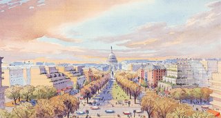 South Capitol Mall at M Street
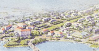 South Capitol Mall at the Anacostia River
Legislation is needed to protect this vista by defining the area between South Capitol and 1st Streets SE at least as north as M Street SE as part of the National Mall, with Half Street SE the line between the linear park and the new adjoining buildings, and extended at least as west as the rear building line of the those along South Capitol Street’s west side.
This is a more constrained use of eminent domain considering the existing demolition to the east, and the relatively low number of dwellings directly along South Capitol Street, and its use for securing pubic space, e.g. all types of roads (including bridges and tunnels), parks, and government buildings, including those open to the public, such as Post Offices and museums.
Extending this new public right of way area further west to Carrollsburg Place or to 1st Street SW (this latter option to mirror that to the east) would require removing the 28 dwellings on each side of each block of these, hence taking upwards of a few hundred south from M Street to P Street SW.
While this was used as the reasoning for NCPC to surrender the western half of its Extending the Legacy/Memorials and Museums South Capitol monumental linear green-way, post 2003 government planning curiously forgets this with all its options illustrated with new and large building on both sides of South Capitol Street, and with what the November 2003 Urban Land Institute “An Advisory Services Panel Report:South Capitol Street Corridor , Washington , D.C. Implementation Plan” says:
Thus accordingly to both the Federal and the District of Columbia governments, preservation overrides public use which are all over-rided by private uses, or IOW eminent domain is unacceptable for public use but acceptable for private use.
Interesting.
Where are any groups working against this perversion of eminent domain embodied by the official planning for the South Capitol Street following the Nationals Stadium's site's appearance in the November 2002 stadium study?
to Save the Mall
for South Capitol Street
 South Capitol Mall at M Street
 South Capitol Mall at the Anacostia River
Legislation is needed to protect this vista by defining the area between South Capitol and 1st Streets SE at least as north as M Street SE as part of the National Mall, with Half Street SE the line between the linear park and the new adjoining buildings, and extended at least as west as the rear building line of the those along South Capitol Street’s west side.
This is a more constrained use of eminent domain considering the existing demolition to the east, and the relatively low number of dwellings directly along South Capitol Street, and its use for securing pubic space, e.g. all types of roads (including bridges and tunnels), parks, and government buildings, including those open to the public, such as Post Offices and museums.
Extending this new public right of way area further west to Carrollsburg Place or to 1st Street SW (this latter option to mirror that to the east) would require removing the 28 dwellings on each side of each block of these, hence taking upwards of a few hundred south from M Street to P Street SW.
While this was used as the reasoning for NCPC to surrender the western half of its Extending the Legacy/Memorials and Museums South Capitol monumental linear green-way, post 2003 government planning curiously forgets this with all its options illustrated with new and large building on both sides of South Capitol Street, and with what the November 2003 Urban Land Institute “An Advisory Services Panel Report:
This challenging area, currently home to a large concentration (907 units) of public housing and a high percentage of the 60 public housing projects located in or near the study area, also includes industrial uses and warehouses of low value. Market pressure on the Southwest waterfront is encouraging the development of more middle-income residential neighborhoods near the water; while more distant properties, located closer to the intersection with South Capitol Street, remain the domain of public housing. No successful redevelopment of the District's Southwest can be accomplished while ignoring the incompatibility of this use with the desired future market.Accordingly the people are to be encouraged to move out over time.
Current residents of this housing stock must be offered incentives to relocate over time in mixed-income housing developments such as the Capper-Carrollsburg HOPE VI project on M Street, east of South Capitol Street. This can and should be accomplished with no net loss of public housing units, while increasing affordable housing choices for low-income residents. Capper-Carrollsburg will incorporate residential and street-level retail, with densities highest along South Capitol Street, and decreasing as development moves in a westerly direction. Re-densification of the area between R and M Streets can accommodate a far greater range of income demographics then is present today, providing a residential environment that supports the overall development of So Cap.
Thus accordingly to both the Federal and the District of Columbia governments, preservation overrides public use which are all over-rided by private uses, or IOW eminent domain is unacceptable for public use but acceptable for private use.
Interesting.
Where are any groups working against this perversion of eminent domain embodied by the official planning for the South Capitol Street following the Nationals Stadium's site's appearance in the November 2002 stadium study?
Subscribe to:
Posts (Atom)


