Monday, July 31, 2006

The Historic Opening
of the East of South Capitol Street vista:


If only temporarily...


(Photos and captions by Jacqueline Dupree)

Looking north into the stadium footprint from South Capitol Street and Potomac Avenue, the southwestern edge of the site, just before demolition began. (04/06)

The same location, six weeks later (May 20). Much of the demolition is finished. (And the Capitol Dome is more visible now, too.) (05/06)

For more photographs, see the stadium page of Jacqueline Dupree's
"Near Southeast" DC Redevelopment site.

http://www.jdland.com/dc/stadium.cfm

In a sense like the NCPC's 1990s promise of opening up the South of the Capitol building vita, only to be quietly scaled back and dropped, the eastern half of this vista will exist briefly as buildings are demolished to make space for new buildings en mass with the Nationals Stadium complex between Potomac Avenue and N Street SE and its northward adjoining "Ballpark District" between N and M Streets SE.

The recent building demolitions for the stadium complex has opened up the vista northward from Potomac Avenue SE to N Street SE. Note her notation: (And the Capitol Dome is more visible now, to.) Yes, "now" as it becomes significantly less visible with the mass of a baseball stadium with its west wall a more 15 feet of South Capitol Street's existing 130 foot wide right of way.

This will happen to north of N Street, with new development projects, such as that of Monumental Reality at the south-east corner of the intersection of South Capitol and M Streets, where the November 2003 ULI SCS Advisory Services Panel Report and the subsequent March 2005 NCPC South Capitol Street pamphlet show with an open square, with the latter showing St. Vincent de Paul Church removed.

Demolition of the existing buildings, such as the storage facility and the Dominos Pizza outlet will likewise open up this South Capitol Street east vista temporarily between Nationals Stadium and St. Vincent de Paul Church.

If this latter demolition happens prior to Nationals Stadium's erection arises again block this vista, the entire eastern South Capitol vista from Potomac Avenue SE to St. Vincent de Paul Church to be visible for a short period of time, if only for a few months, weeks, or even days.

Sunday, July 30, 2006

The Constructural Rough Edge
(or Achilles Heel)
of the stadium jammed along South Capitol Street
within that Spring 2008 deadline

Note that the construction's consumption of its emergency contingency fund so far.

Note the rainy season... and the soil permeability ... and that concrete curing is a science ... and that moisture is a factor ...

Note that deadline... the start of the 2008 baseball season in early April...

Will this all conspire in some way or another to produce a compromised product?

If so, it sends a message that satisfying the dream of some well-connected person who may perhaps not live past 2008 is more important than a long life product that would endure.

Saturday, July 29, 2006

The Contractual Rough Edge
About National's Stadium's
Above-Ground Parking


From Jacqueline Dupree:
Mayor Calls for Cease Fire with Lerners
(7/27 9:02 AM) From the Post: "D.C. Mayor Anthony A. Williams called yesterday for a meeting to restore goodwill between city officials and the new owners of the Washington Nationals, saying that the family of Bethesda developer Theodore N. Lerner had been "condescending" in dealings with the city." Tony got in a few good licks: " 'We're both in this,' Williams said. 'You put up $450 million for the team. Well, we put up $611 million for the stadium, and we're trying to get some benefits for our people. Excuse me, we do not need the condescending attitude. Maybe I have not built a stadium, but we brought $40 billion of investment to this city. Someone must think we know what we're doing.' " Team president Stan Kasten attempted to dial back the hostilities by releasing a statement saying "The new Nationals ownership has nothing but appreciation and respect for the enormous work and political courage of Mayor Williams and the D.C. Council in making big league baseball a reality in the Nation's Capital. We have been consistently supportive of their commitment to Major League Baseball to deliver a first class ballpark on time and on budget." [snarky emphasis mine] Other tidbits in the article: Herb Miller is scheduled to present his financing plan for The Garages Wrapped With Development Goodness to the DC Sports and Entertainment Commission on Monday. And the Mayor has said that he would go to the council for more money (up to $83 million according to CFO Gandhi) if the Miller plan falls through. The WashTimes has a similar article, with the additional info that after the financing plan is presented to DCSEC on Monday, they will vote on it on Wednesday; at that point, it would then need the Lerner group's approval for it to move forward.
This centers around the stadium contract's requirement for its on-site parking spaces to be operational by the stadium's April, 2006 scheduled opening, with the lack of any contractual requirement that the these be underground; hence these parking spaces were to be in above-ground multi-level structures.

Placing this parking partially or entirely underground will raise this stadium's acknowledged costs to over $700 million.

It is not known to this blogger if this issue about underground versus above ground parking was even mentioned anytime in the negotiations between the District of Columbia government and MLB over this whole Nationals Stadium fiasco.

Friday, July 28, 2006

Herb Miller
of Western Development

Herb Miller of Western Development, (3rd from left); with D.C. Councilmember Jack Evans; Washington Nationals President Stan Kasten; and DC Sports and Entertainment Commission board member and Winston & Strawn attorney William Hall. Illustration from The Washington Post.

From Jacqueline Dupree:
All About Herb
(7/24 11:00 PM) "Behind the Vision for a Ballpark District is a Man of Big Ideas" is a front-page story in Tuesday's Post about Herb Miller, the DC developer who persuaded the Mayor and the City Council to take a chance on his $300 million plan to wrap the 900 required parking spaces at the north end of the new Nats ballpark with condos, retail, and a hotel. (I'd quibble with the sense from the headline that this project is the entire Ballpark District, because it's not, but we digress.) While the plan has passed the City Council, it still requires approval from the Lerners (cue ominous music), who according to the article refer in private to the two structures as "Godzilla" and "Mothra" (scroll to the first rendering on my ballpark page to see the design as submitted to the Zoning Commission in June). The Lerners are to review Miller's plans and financing strategy early next month. So no, it's still not over. UPDATE: Wow, they changed the headline, it's now a much better "DC Developer Sways the City with Big Bucks and Big Ideas."
From DCist:
(July 12, 2006) Yesterday, at its last meeting before taking their summer recess, the D.C. City Council approved the sale of a large parcel of land which sits north of the new Nationals stadium site along South Capitol Street and N Street SE to developer Herb Miller, for $61 million. As part of the deal, Miller will include a large stadium-dedicated parking lot with 925 spaces for cars in his planned mixed-use development, which will count toward the 1,225 parking spaces required to be built by the city, according to their deal with Major League Baseball.
Herb Miller of Western Development Company not only helped persuading DC officials to approve the mixed use condo garages along the south side of N Street SE, but also the new baseball stadium itself jammed along the east side of South Capitol Street.

In particular, Herb Miller has played a role with persuading DC Councilmember Vincent B. Orange Sr.:
Tuesday, April 11: Orange parties with developer Herb Miller at his Georgetown mansion! To celebrate Orange's 49th birthday--and allegiance to spending more than $600 million on a baseball stadium--Miller is throwing a shindig normally reserved for politicos like neighbor Jack Evans. The host committee includes hardball devotees--D.C. Sports and Entertainment Commission members Mark Tuohey and William Hall--as well as slots lovers John Ray and Pedro Alfonso.
http://blog.washingtonpost.com/dcwire/2006/04/april_is_vincent_b_orange_sr_m.html


Thursday, July 27, 2006

Nationals Stadium 'Public' Faces
Plausible Dupes for the Desecration
of US NCPC's
Extending the Legacy Planning


Nationals MLB Franchise Owners:
The Lerner Group


May 3, 2006: Mark D. Lerner, Theodore N. Lerner, Stan Kasten, Robert K. Tanenbaum, Faye Fields and Rodney E. Slater, members of the Lerner Group, at a press conference at the Fairmont Hotel in the District, announcing their selection by MLB' Selig, culminating a months long competition for the privilege to purchase this Washington Nationals baseball team franchise for the $450 million price set by Major League Baseball's member teams. Illustration from (The Washington Post)


http://www.washingtonpost.com/wp-dyn/content/article/2006/05/03/AR2006050301121.html
http://www.washingtonpost.com/wp-dyn/content/article/2006/05/02/AR2006050202006.html

July 2003: The Lerner Group's purchase of this Washington Nationals MLB team franchise is formally finalized.
The Washington Nationals today announced the official transfer of ownership from Major League Baseball to an ownership group headed by Washington developer Theodore N. Lerner, his son Mark D. Lerner, sons-in-law Edward L. Cohen, and Robert K. Tanenbaum, and their families. Ted Lerner will be the Managing Principal Owner of the team and Mark Lerner, Cohen and Tanenbaum will be Principal owners of the team. All major decisions will be made together as a board with team President Stan Kasten. In addition, the members of the minority ownership group each have deep ties to Washington, DC and a shared commitment with the Lerner family to make the Nationals a long-term successful franchise in Washington.

"It has long been my dream to bring the national pastime back to my hometown, the nation's capital," said Ted Lerner, Managing Principal Owner. "Now that it's been realized, I plan on doing everything I can to make sure that this franchise becomes an international jewel for MLB, D.C. and the nation."

Founding Partners in the Lerner group are Paxton K. Baker, President of BET Event Productions and Executive Vice President and General Manager of BET Digital Networks for Black Entertainment Television (BET); James T. Brown, newly-named host of the CBS Television Network's NFL pre-game show, The NFL Today, and the play-by-play announcer for the Network's coverage of college basketball; Faye F. Fields, President and CEO of Integrated Resource Technologies, Inc., a leading provider of management support services and information management services to government agencies; Alphonso Maldon, Jr., Senior Vice President, Corporate Banking for PNC Bank and former Assistant Secretary of Defense for Force Management and Policy; B. Doyle Mitchell, Jr., President and CEO of Industrial Bank N.A., the largest minority-owned commercial bank in the Washington D.C. Metropolitan Area; Raul R. Romero, President and CEO of Alliance Consulting Group, LLC, a marketing consulting group to public and private organizations headquartered in the District of Columbia; Rodney E. Slater, partner at Patton Boggs, LLP and former U.S. Secretary of Transportation; and Jarvis C. Stewart, Chairman and Managing Partner of Stewart Partners, LLC, a government and Public Affairs Firm headquartered in Washington, D.C.
http://mlb.mlb.com/NASApp/mlb/news/press_releases/press_release.jsp?ymd=20060724&content_id=1572870&vkey=pr_was&fext=.jsp&c_id=was

The Lerner's Washington Nationals ownership group's principle members include:

http://www.lernerenterprises.com/newsArchives/natsLernerFamily.html
http://www.lernerenterprises.com/newsArchives/natsAdBios.html


Mark D. Lerner
Mark D. Lerner is a principal of Lerner Enterprises, which was founded more than 50 years ago by his father, Ted Lerner. The company's development activity is mainly concentrated in the D.C. metropolitan area and includes numerous major office, retail, hotel and residential projects. Currently he is a member of the Board of Directors of the Charles E. Smith Jewish Day School in Rockville, Md., and also serves on the several other boards. He is vice president of The Annette M. and Theodore N. Lerner Family Foundation, which provides support to many worthwhile organizations.
http://www.washingtoncaps.com/team/lerner.asp

Theodore N. Lerner
, father of Mark D. is a founding partner of Lerner Enterprises, a real estate development entity, who has long expressed interest in owning a professional sports team:
Balancing vision and innovation with experience and integrity, Lerner Enterprises has been a respected leader in Washington area development. Its founding partner, Theodore N. Lerner, established principles early in his career which he and his family have maintained in guiding the family-owned and operated organization.

Well known for its involvement in high-profile properties such as White Flint, Tysons II, White Flint North, Washington Square, Dulles Town Center and Tysons Corner Center, Lerner Enterprises develops and their affiliate Lerner Corporation leases and manages large scale office buildings, office and business parks, regional malls and shopping centers, hotels, residential communities, mixed-use facilities and land development projects. More than 20 million square feet of commercial and retail space, as well as more than 22,000 private homes and 6,000 apartment homes, comprise an impressive portfolio, a portfolio which illustrates the diverse capabilities of Lerner Enterprises to plan, develop, and construct well-designed and high-quality properties to their greatest potential.
http://www.lernerenterprises.com/corporate.html
When Theodore N. Lerner was a young man growing up on Fifth Street in Northwest, he would walk several blocks to Griffith Stadium, where the future real estate mogul took a job as an usher because he couldn't afford to buy a ticket to watch the Senators.

"I didn't have the money for admission in those days -- I think it was less than 50 cents a ticket -- so I took a job as an usher to get in," Lerner said. "My dream was some day to be the owner of the team." After three decades of failed attempts to buy a Major League Baseball team, Lerner, 79, is now the closest he has ever been to fulfilling his dream. He and his close-knit family, who operate a vast real estate empire in the Washington region, are among the leading contenders of the eight bidders for the Washington Nationals.

"After the heartbreak of seeing our Senators leave the city twice, I never thought that I'd ever see big league baseball return to D.C. in my lifetime," Lerner said. "Now that it is back, I am deeply committed to assuring that it remains here, is played in a first-class facility which people can enjoy, and is operated in a way that brings the community a common source of pride and joy that serves as a community bond. I hope this will be a lasting legacy I can leave to my family and to the community where I was born and raised."
http://www.washingtonpost.com/wp-dyn/content/article/2005/11/03/AR2005110302067.html

A legacy of stopping the extension of another legacy.


Stan Kasten,
an Atlanta, Georgia professional sports executive, was selected to be the President of the Washington Nationals.

http://
www.businessofbaseball.com/kasten_interview.htm
http://www.washingtonpost.com/wp-dyn/content/article/2006/04/18/AR2006041800959.html
nt/article/2006/04/18/AR2006041800959.html
http://www.harrywalker.com/speakers_template.cfm?spea_id=779
http://bobnebel.tripod.com/kastenprofile.html


Robert K. Tanenbaum
, is one of Theodore Lerner's son-in-laws.
Robert K. Tanenbaum, who has lived in the Washington, D.C. area for more then 35 years, is a Principal of Lerner Enterprises, the largest private real estate developer in the Washington, D.C. area. He is also a Principal Owner of the Washington Nationals Major League Baseball team. He is a graduate of Union College and The George Washington University National Law Center. Mr. Tanenbaum is on the Board of Imagination Stage, a local theater arts center that nurtures young people of all abilities through participation in professional theater arts education experiences. He and his wife are also involved in a variety of other educational, political and community activities.
http://www.lernerenterprises.com/newsArchives/natsLernerFamily.html
Edward L. Cohen, is also one of Theordore Lerner's son-in-laws.
Edward L. Cohen, who has lived in Washington, D.C. for almost 40 years, is a Principal of Lerner Enterprises, the largest private real estate developer in the Washington, D.C. area. He is also a Principal Owner of the Washington Nationals Major League Baseball team. He graduated from the University of Pennsylvania and from Georgetown University Law Center. Mr. Cohen has been a member of various corporate, charitable, and educational boards. He presently serves on the Board of Directors of The Weizmann Institute of Science and on the Board and Executive Committee of Junior Achievement of the Greater Washington Area.
http://www.lernerenterprises.com/newsArchives/natsLernerFamily.html
The Lerner’s Washington Nationals ownership group’s other members include:

Paxton K. Baker,
President of BET Event Productions and Executive Vice President and General Manager of BET Digital Networks for Black Entertainment Television (BET)

James T. Brown,
newly-named host of the CBS Television Network's NFL pre-game show, The NFL Today, and the play-by-play announcer for the Network's coverage of college basketball

Faye Fields,
President and CEO of Integrated Resource Technologies, Inc., a leading provider of management support services and information management services to government agencies:
She has 30 years of corporate organization development and management experience with 20 years experience managing Federal Government contracts from start-up to completion for military and civilian organizations. She formed IRT in 1986 growing from $200,000 in 1998 to over $10 million in revenue in 2004. The company grew over 40%per year from 2000-2004. She holds a BS and MS from the University of Cincinnati, and completed all of the course work for a PhD in Business Administration at the University of Cincinnati. http://www.irti.com/


Alphonso Maldon, Jr.,
Senior Vice President, Corporate Banking for PNC Bank and former Assistant Secretary of Defense for Force Management and Policy;


B. Doyle Mitchell, Jr., President and CEO of Industrial Bank N.A., the largest minority-owned commercial bank in the Washington D.C. Metropolitan Area;


Raul R. Romero, President and CEO of Alliance Consulting Group, LLC, a marketing consulting group to public and private organizations headquartered in the District of Columbia;


Rodney E. Slater, former Administrator of the U.S. Federal Highway Authority (1993-1997), and the U.S .Department of Transportation (1997-2001), who is currently an attorney at the Washington, D.C. law firm Patton and Boggs, specializing in:
Transportation and Infrastructure
Public Policy and Lobbying
Defense and National Security
Former U.S. Secretary of Transportation Rodney E. Slater helps clients integrate their interests in the overall vision for the transportation system of the 21st Century—a vision he set as transportation secretary to promote a safer, more efficient, environmentally sound and sustainable worldwide transportation infrastructure. Mr. Slater also helps state and local government clients address the vexing challenge of closing the gap between transportation demand and capacity by employing public/private strategies and innovative financing solutions. Mr. Slater's practice focuses on many of the policy and transportation objectives that were set under his leadership, including aviation competition and congestion mitigation, maritime initiatives, high-speed rail corridor development, and overall transportation safety and funding. He continues to embrace the framework he established as secretary for making transportation decisions that called for more open, collaborative and flexible decision making across the transportation enterprise here and abroad.

Mr. Slater’s bipartisan and inclusive approach to problem solving has earned him tremendous respect and admiration on both sides of the aisle, enabling him to have one of the best relationships with the White House, Congress, and business, labor and political leaders worldwide in the history of the Department of Transportation (DOT). His work at DOT forever altered America’s and the world’s appreciation of transportation as more than just concrete, asphalt and steel. Mr. Slater brings the same strategic, results-oriented and collaborative approach to his public policy practice.

As secretary of transportation under President Bill Clinton, Mr. Slater passed several historic legislative initiatives over his tenure, including the Transportation Equity Act for the 21st Century (TEA-21), which guaranteed a record $200 billion in surface transportation investment though 2003, and the Wendell H. Ford Aviation Investment Reform Act for the 21st Century (AIR-21), which provides a record $46 billion to improve the safety and security of the nation’s aviation system. Under his leadership, the federal transportation budget doubled and in the department’s "best in government" strategic and performance plans, the scope and definition of transportation was expanded to include a focus on safety, mobility and access, economic development and trade, the environment and national security.

Previous to his tenure as transportation secretary, Mr. Slater served as director of the Federal Highway Administration, where—as the agency’s first African-American Administrator in its century-long history—he oversaw the development of an innovative financing program that resulted in hundreds of transportation projects being completed two to three years ahead of schedule with greater cost efficiencies. Over that time, the federal transportation budget increased an unprecedented 104 percent. Additionally, the department’s FY2001 budget of nearly $60 billion is the largest ever.

Professional Affiliations:

Former Secretary of Transportation
Former Administrator of the Federal Highway Administration
Former Director of Government Relations, Arkansas State University
Former Special Assistant for Economic and Community Programs to then-Governor Bill Clinton
Former Executive Assistant for Community and Minority Affairs to then-Governor Bill Clinton
Former Assistant Attorney General, Litigation Division of the Arkansas State Attorney General’s Office
Former Secretary-Treasurer, Arkansas Bar Association
Special Liaison, Martin Luther King Jr. Federal Holiday Commission
Arkansas State Highway Commission, (1987-1992)

Rodney E. Slater was named Secretary of Transportation on February 14, 1997. He is the 13th Secretary in the 30-year history of the Department, and only the third Arkansan in American history to ever hold a position in the President's cabinet.

President Clinton said in nominating Slater: "he has built bridges both of steel and of goodwill to bring people closer together." As Secretary, Slater is working to build the President's bridge to the 21st century as well as the nation's airports, highways, railroads, mass transit, and maritime resources. The Department, which has 100,000 employees and a budget of more than $40 billion, also includes the United States Coast Guard.

As Secretary, Slater likes to say:
"I believe that transportation is about more than concrete, asphalt, and steel. It is truly about people and providing them the opportunity to be successful and responsible individuals."

Under his leadership, the Department developed a strategic plan that Congress rated the best among all federal agencies. He also worked with Congress to increase investments in infrastructure by 12 percent in fiscal 1998, to the highest levels of any Secretary in history.


So, what is Slater's position on the South Capitol Street corridor's vehicular tunnel that was proposed in the 2003 NCPC and DCDOP reports, but which gets sidelined by the November 2003 Urban Land Institute Advisory Services Panel Report in favor of expedited real estate development?

Likewise, what's his position on placing the new Nationals Stadium so close to a future planned RR? The site is within 1/3 of a mile of the existing through D.C. heavy RR, which is roughly the distance between RFK to the RR further east. But it's within only 250' or so of where that RR is planned to be relocated into a new RR tunnel, for a RR that might allow HAZMATs including chlorine, of which a terrorists' derailment could kill 60,000 people in and around Capitol Hill, with this stadium potentially upping that figure by 41,000 to just over 100,000. Would this tunnel be able to contain such chemicals?

This is of course assuming that the authorities adopt the alternative proposal of routing freight into this new north south tunnel.


Future D.C. rail tunnel
from "Extending the Legacy: Planning America's Capital for the 21st Century"

Jarvis C. Stewart, Chairman and Managing Partner of Stewart Partners, LLC, a government and Public Affairs Firm headquartered in Washington, D.C.

This blogger is not aware if this list of investors is necessarily all inclusive.


SP-Owners Photos by Michael Williamson 5/03/06 -- New Nationals owners and wives pose for a group shot.NAMES: From left to right (back row) Mark Lerner, James T. Brown, Edward L. Cohen, Jarvis C. Stewart, George Munoz, Paxton K. Baker, Theodore Lerner, Rodney E. Slater, Raul R. Romero, Stan Kasten and Robert Tanenbaum. From left to right (front row) Judy Lerner (Mark Lerner's wife) Debra Cohen (Edward L. Cohen's wife), Annette Lerner (Ted Lerner's wife) Marla Tanenbaum (Wife of Robert Tanenbaum) Faye F. Fields and B. Doyle Mitchell Jr.

http://www.washingtonpost.com/wp-dyn/content/article/2006/05/03/AR2006050301121.html?referrer=email">http://www.washingtonpost.com/wp-dyn/content/article/2006/05/03/AR2006050301121.html?referrer=email

Wednesday, July 26, 2006

MLB asking for an additional $83 million from DC taxpayers

From Jacqueline Dupree:
Today's Garage News
(7/26 8:40 AM) From the Post: "The District's chief financial officer has told Mayor Anthony A. Williams (D) that the city will need up to $83 million in additional funds for construction of parking garages near the new baseball stadium if a plan from a private developer to finance the structures falls through. [...] But the report from Natwar M. Gandhi said the mayor will have to seek money from the city's general fund or approval for more construction bonds from the D.C. Council if Miller cannot make good on his proposal. Miller will try to win final approval from the Washington Nationals ownership group next week. The city has $21 million to build free-standing garages, but because the D.C. Zoning Commission approved Miller's plan for integrated development, the District would need more money, officials said." And here's the WTOP piece, headlined "Stadium Price Tag May Go Up Nearly $100M", which has more detail, saying that " Gandhi briefed the Mayor on three options that would promote revenue opportunities [...] One option would cost $44 million, another $58 million. Both options would provide 1,225 parking spaces. A third option would cost $98 million and provide 1,875 parking spaces, bringing the total stadium price to more than $700 million. At a recent stadium task force meeting, D.C. Council members were told they would need to amend the current stadium legislation to wave the cap on spending and approve the additional costs. If Miller's plan falls through, the additional costs could be covered by issuing more construction bonds, or the mayor could seek the money from the city's general fund. The additional spending would not be submitted to the council for a vote until after after the September primary." So now we wait to see if Herb gets his financing in place (though I remember reading somewhere that he had said he would have the financing for excavation in place by mid-August, and the rest of the financing ready by the time real construction would start, late in 2006, but who knows how CFO Gandhi feels about that), and whether the Lerners approve the plan.

WTOP piece comments:
http://www.wtop.com/index.php?nid=25&sid=861039&comments=true
So much for the DC Council's stadium construction "spending cap."

Sunday, July 23, 2006

The New Stadium Condo-Garage


Illustration from Jacqueline Dupree http://www.jdland.com/dc/stadium.cfm

Note the ghost outlines of the new development to surround this stadium. South Capitol Street becomes more like K Street NW.

Note the space between the condo-garage buildings to see that exactly the western half of this complex directly conflicts with U.S. National Capital Planning Commission's (NCPC) "Extending the Legacy" South Capitol Mall.

What a waste of an opportunity, of time, of money, and of the NCPC's credibility.

Only the eastern of these two condo garages is likely to survive the post epiphany demolition of this misplaced complex.

Saturday, July 22, 2006

Physical Reality:
The only structure along South Capitol Street likely to survive the re-developement: St. Vincent de Paul Church, at the north-east corner of South Capitol's intersection with M Street, first opened to the public April 1904.

http://www.parishes.org/vincentdepaul.html
http://www.adw.org/home.asp
http://www.adw.org/about/lead_bio_mccarrick.asp


The third illustration shows St. Vincent de Paul Church relocated approximately 250 feet east to retain its historic position at the north east corner if the intersection of South Capitol and M Streets, with the intersection reconfigured to accomodate the green way.

This would not have been the first time that a historical religious structure was relocated for a public purpose. In 1969 this was done, with a far greater distance of relocation, with the Adas Israel Synagogue -- Washington, D.C.'s oldest extant synagogue that first opened in 1876 -- which was moved 4 blocks to accommodate WMATA subway construction.


In 1969 the Adas Israel Synagogue was lifted up from its historic location at the corner of 6th and G Street NW, for a 4 block trip to its current location at 3rd and G Street.

This relocation placed this Synagogue next to the portion of the below grade I-95 (I-395) Center Leg, constructed from the SW Freeway to Massachusetts Avenue NW (1966-1973). It is immediately at the southbound on-ramp to the freeway, where this ramp would not allow adding a continious deck, being hidden from view from the ramp by a row of trees, which are visible to the left in the photo below.


Although the I-95 Center Leg is now known as the I-395 3rd Street Tunnel (having two cut and cover tunnel segments, one beneath the Mall as part of the 1966-1973 project; and a second segment northward from Massachusetts Avenue NW to K Street NW, in a latter 1978-1982 project), this segment is not a tunnel, and which lacks even cross over bridge for either G or F Streets NW.


The far shorter needed relocation of St. Vincent de Paul Church would avoid lifting it onto the streets, via an excavation to its rear allowing it to be moved laterally, with the excavation continuous to its new location at what is now Half Street SE. Such an excavation would have the added benefit of creating new underground space for parking facilities, and for a portion of a parallel vehicular tunnel, saving millions of dollars.


Illustration: http://www.jdland.com/dc/20m.cfm (Jacqueline Dupree)

This blogger is not aware of any formal consideration given to this idea, nor any media references at all to the St. Vincent de Paul Church/South Capitol Mall issue, nor anything about negotiations between D.C. and U.S. government and Roman Catholic Church officials.

However, that pit, which is directly behind St. Vincent de Paul Church, is the substructure for a new office building -- 20 M Street -- which started construction about September 2005. This new building, the first to be built within the one block to either side of South Capitol Street, is perfectly situated to block the idea of this easiest relocation. Note the rear of St. Vincent de Paul Church to the left in this rendering.

20 M Street web site:
http://www.20mstreetse.com/Lerner Enterprises web site:
http://www.lernerenterprises.com/

20 M Street is a project owned by Lerner Enterprises, which is headed by Theodore Lerner, born in 1925 in Washington, D.C. On May 4, 2006 it was publically announced that he had been "chosen" to purchase the Nationals baseball team franchise that will run the new Nationals Stadium that will be built on this same -- east -- side of South Capitol Street, directly 2 blocks to the south.


Cardinal Theodore E. McCarrick, Ph.D., D.D.
Archbishop of Washington Dioceses, which runs St. Vincent de Paul Church.

McCarrick, born July 7, 1930 in New York City, was installed as Archbishop of Washington on January 2, 2001, and held that position until May 16, 2006. He is listed as a member of the Board of Trustees of the Catholic University of America in Washington, D.C. NE at: http://publicaffairs.cua.edu/factbook/trustees.htm

Biography at: http://www.adw.org/about/lead_bio_mccarrick.asp


Illustration: crop from 2002 D.C. Baseball stadium study with St. Vincent de Paul Church shown as the sole surviving existing building along South Capitol Street's east side.

Friday, July 21, 2006

March-April 2008 must be a historically important date

By yet another such indication, Major League Baseball Inc. insists that its blot upon the
Extending the Legacy South Capitol Mall concept be completed in time for the opening of the 2008 season.

From Jacqueline Dupree:
MLB Says DC in Default on Lease Agreement

(7/21 11:41 AM) New from the Post: "Major League Baseball has declared the District government in default of the lease agreement for the new stadium, charging that the city has failed to meet several deadlines for turning over critical documents.In a letter to city officials Tuesday, Tom Ostertag, a lawyer for MLB, said the city had failed to meet 11 provisions called for in the construction administration agreement between the District and MLB." What does this mean? "Some city officials interpreted the default notice as a legal maneuver meant to establish firm deadlines in case the stadium project ever ends up disputed in the courts." Quoth incoming Nats president Stan Kasten: "We're doing all we can to build this team and to excite the fans again about life at RFK. And we're having trouble getting the simplest things done. We keep getting foot-dragging. . . . It does weight us down as we try to move forward. And we keep getting silly roadblocks that stop us." On the other side: "Mark H. Tuohey, chairman of the D.C. Sports and Entertainment Commission, said lawyers for the city's attorney general's office are working on finalizing more documents to give MLB and that most of the baseball's concerns would be resolved today." UPDATE, 3:03 pm: Here's the official notice from MLB. UPDATE, 12:24 pm: Here's a nifty opinion piece by the Post's Steve Perlstein basically telling both sides to get a grip: "Less Hardball, More Humility." And here's the WashTimes story on the default.
Looks like that those D.C. City Coucilpersons that voted in favor of this planning blot may get to eat crow. And to think that the D.C. City Council had voted to reject this blot, only to reconvene towards midnight to re-vote in favor of this blot.

Is it any wonder that the Councilpersons who ultimately voted to approve this blot are not too favorable of requirements that such meetings be open to the public; perhaps they would be embarrassed to be seen making such decisions with such little open discussion.

Perhaps their arms were twisted because some rather influential person somewhere in this story who has this blot as his or her dream, but who has some sort of incurable disease and hence the project deadline is in order for this person to see his or her's dream while he or she is still alive? Someone who may not live to see 2009.

Who knows?

Thursday, July 20, 2006

The Logic of the 2002-2004 South Capitol Mall Deletion

The 2003 studies exclude the basic Mall option for a reconfigured South Capitol Street presented in NCPC's Extending the Legacy and Memorials and Museums. NCPC's South Capitol Street Urban Design Study, did this in response to community outreach meetings in 2002, where people from neighborhoods including those along Carrollsburg Place and Half Streets SW, expressed their sentiment that they did not want to have their dwellings removed for the new parkland and/or the new adjacent buildings. Hence this 2003 report included two drastically scaled back linear park proposals: its options "c" and "b". These had very little property acquisitions to the west, avoiding the Carrollsburg Place and Half Street neighborhoods, limiting residential displacement west of South Capitol Street to directly along that street south of N Street. Because of a dearth of dwellings to the east, options "c" and "b" would have displaced about 5 residences, including the Alfred Richards House that was last privately owned by Ken Wyban, which were demolished in May, 2006. Although this study would cite the need to establish a linear park along the South Capitol Street corridor, it included a 3rd option, “a” that would not widen the right of way, but instead provide a linear park in the form of sidewalks that would be widened by eliminating a parking lane.

To help the authorities decide among these 3 options, the 2003 NCPC South Capitol Street Urban Design Study list the following as their advantages and disadvantages:

For Option “c” with its 195’ wide linear park offset to the east:
Advantages:
New monumental public realm;
Continuity of public realm established between mall and the Anacostia River parks system;
Reinvestment in the area may be attracted by the appearance and the scale of the new South Capitol Street environment.
Disadvantages:
Substantial land takings required east of South Capitol Street;
Most complex and costly of the three to implement;
Requires negotiating with Navy to allow crossing to take most southerly location.
For option "b" with its 220' total right of way with a 100' wide median greenway:
Advantages:
Central median can accommodate series of smaller memorials;
Continuity of public realm established between mall and the Anacostia River parks system;
Reinvestment in the area may be attracted by the appearance and the scale of the new South Capitol Street environment.

Disadvantage
Substantial land takings required including existing housing east and west of the present South Capitol Street ROW.

For option “a” to not widen the existing 130’ South Capitol Street ROW:

Advantages:
Few land takings
Modest adjustments to South Capitol Street
Maximum land for redevelopment

Disadvantages:
Lacks a compelling vision for South Capitol Street
Few opportunities along corridor for memorials, etc.
Limited incentive for additional investment.
By choosing option “a”, the authorities valued an opportunity for extending the monumental core as less important then not infringing upon maximizing the sheer amount of square footage for new real estate development: squandering a unique opportunity for the more mundane by this above criteria. By their admission they selected the option that “lacks a compelling vision for South Capitol Street, in order to minimize property acquisitions for expanding a public right of way, so as to maximize real estate development square footage, while ultimately preserving only one building: St. Vincent de Paul Roman Catholic Church.

Curiously it calls option “c” as most complex and costly, despite the space it provides for a cut and cover tunnel alongside South capitol Street, being the easiest to construct while maintaining the existing South Capitol Street traffic.

This charge of being “most complex and costly” ignores the reality that the buildings along this right of way for the tunnel beneath essentially the eastern half of NCPC’s 1990s through 2001 South Capitol Mall concept, are being cleared anyway, with the sole apparent exception of the St. Vincent de Paul Church. Look at what's happening along South Capitol Street's east side now, in 2006, with demolition for Nationals Stadium clearing every building from Potomac Avenue northward to N Street demolished May-June 2006; and threatening the storage building northward to M Street for a new development project by Monument Reality that may or may not conflict with the Urban Land Institute’s 2003/NCPC’s 2005 proposal for a “town square” at the intersection of South Capitol and M Streets, with additional development projects envisioned for the open parking lots and the McDonalds fast food restaurant northwards from the St. Vincent de Paul Church, which is the sole structure blocking this east-offset tunnel route to the ramps to the SW/SE Freeway.

This charge of “most complex and costly” fails to distinguish between the offset to the east linear park and the tunnel beneath, hence avoiding any consideration of running the tunnel directly under South Capitol Street, with any substantial linear park truncated to go no further north of M Street to avoid a conflict with a position of not demolishing, deconstructing or even relocating St. Vincent de Paul Church. After all, this Church would be the only structure in the path of the offset to the east tunnel and linear park of option "c".

All of the 2003 and later planning documents AFAIK but NCPC’s 2005 report reflect this by showing St. Vincent de Paul Church in its existing location. This includes the November 2002 stadium study where the Nationals Stadium site appears as the mis-named "M Street" option, as well as the Passonneau and Associates illustration that Joseph Passonneau included in his August 2000 slide show presentation at the National Building Museum.

Wednesday, July 19, 2006

Without Debate

From Jacqueline Dupree, Near Southeast Washington:

Council Passes Stadium Parking Plan Without Debate
(7/11 8:12 PM) More to come when news stories are posted, but I can report that the city council today passed without debate PR 16-852, the resolution to sell some of the stadium property right along N Street to developer Herb Miller, so that he can build not only the 925 parking spaces required by MLB but also a mix of residential, retail, and hotel offerings. (Without debate! Will wonders never cease!) Now the real fun begins, seeing whether he can actually pull this off on schedule and on budget. While it's quite a gamble, I don't think there's many residents who would have preferred two aboveground parking garage-boxes rather than mixed-use offerings in this location. Now we'll just see whether the gamble pays off. Batter up, Herb. UPDATE: here's the Post story, including that news that Miller "intends to produce the first $5 million or $6 million [of financing] in September to start excavation of the land, and the bulk of the financing would come by Dec. 1." UPDATE, 9:48 am: And here's the WashTimes story. UPDATE, 7:39 pm: And a late addition, this Examiner story says what I've suspected all along: "In its unanimous support of developer Herb Miller's project, to be built on two city-owned parcels adjacent to the ballpark's north end, the council sent a message, members said: Major League Baseball has long had the city over a barrel, but not in this case. " 'It's the first time the council has stood up and said, "This is ours," said Ward 5 Council Member Vincent Orange. "These are our development rights." ' "
Alas this is has been hardly uncommon with the planning for the South Capitol Street corridor itself, with no evident open debate or even an explicit discussion about the deletions of proposed linear parkland, the existing residential neighborhoods to the west, and the role or impact regarding St. Vincent de Paul Church at the northeast corner of the intersection of South Capitol and M Streets.

Monday, July 10, 2006

What could be done instead:
Improve RFK area accessibility


While RFK already has a relatively adequate WMATA stop, (in contrast to the South Capitol Street area), Washington, D.C. has a seriously truncated highway system that has yet to be completed, and which falls short of serving the RFK area. Hence, in contrast to the official planning which pretends to provide for a multi-model and comprehensive transportation network, the focus here is on providing the missing segments of highway.

Extend the SE Freeway Barney Circle Underpass to East Capitol Street, taking advantage of the topography to build a cover over the existing SE Freeway to the west towards the 11th Street Bridge[s], and over the extension to the east, this placing most vehicular traffic underground beneath new parkland and a local slow speed road with a new terrace to the waterfront, extending the Washington, D.C.'s monumental core beauty along the Potomac River by the Lincoln Memorial to the Anacostia River.

The topography allows this underground SE Freeway to be constructed relatively inexpensively without excavation for the entire segment that follows the axis of the Barney Circle Underpass since this highway runs across a hill; the segment towards RFK/East Capitol Street would be a cut and cover tunnel through existing right of ways and parking lots. The most challenging portion is the transition between these two segments at the southeast corner of Congressional Cemetery.

This would not build the Barney Circle Bridge that was officially proposed from 1983 to 1996.

The current Middle Anacostia Transportation Study hints at this idea of such a topographically advantageous cover for the existing SE Freeway segment as a tunnel without any new excavation; it does so with various cross-section illustrations, accompanied by a total lack of any acknowledgment of this idea, with the space simply labeled "development".

This study shows different options, including those that abandon even the existing Barney Circle Underpass, and those that drastically reduce the public right of way by selling off much of the existing SE Freeway right of way for new private real estate development.
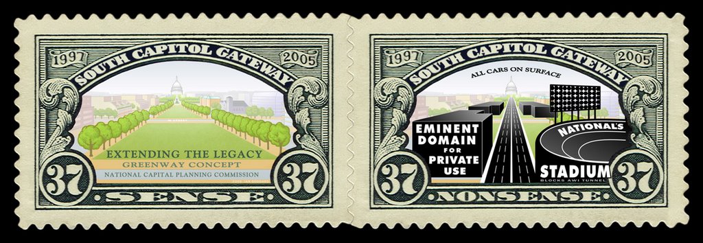
Extend a covered – tunnel – SE Freeway to RFK, topped by a new monumental terraced waterfront promenade and surface road


Between the 11th Street Bridges and Barney Circle, the westbound traffic capacity of the SE Freeway is underutilized while its eastbound capacity is bottlenecked by the SE Freeway’s truncation at Barney Circle and its consequential diversion of traffic across the Pennsylvania Avenue/Sousa Bridge to the incomplete interchange with the Anacostia Freeway, which runs along the continuous length of this south or east side of the Anacostia River, reducing local access to the adjoining neighborhoods, such as Hillcrest.

Failing to extend the SE Freeway to RFK Stadium diverts traffic from the truncated SE Freeway on the west side of the Anacostia, to a bridge to the east side of the Anacostia River places a disproportionate proportion of the traffic burden on the neighborhoods It does protect local accessibility along the waterfront area of the Anacostia west shore in the area around Congressional Cemetery, part of which is now lined by a surface RR, but it reduces the SE Freeway’s utility, while doing nothing to remove the local barrier effect of the existing SE Freeway segment to Barney Circle’s west, nor those of the fully continuous I-295/DC Route 295 Anacostia Freeway on the other side of the river.

Best serving the principle of environmental justice would be to protect and promote these concerns broadly and fairly, with equivalent environmental mitigation for neighborhoods on both side of the Anacostia River translates to both reconstructing existing freeway segments with improved designs that feature greater operation ability, safety and environmental mitigation, particularly tunnels to contain noise, air pollution and run-off such as brake dust, with such standards applied to extending the SE Freeway to RFK Stadium.

RX:

West of the Anacostia River

Extend a tunneled SE Freeway to RFK stadium/East Capitol Street, doing this relatively good economy of scale via taking advantage of the topography to avoid the significant expense of excavation for much of the route, and with significant local benefit in improving RFK area accessibility, with a new highway cover that would essentially serves as an western and an eastern extension of the current island of Barney Circle.

The existing SE Freeway could be made into a tunnel with its full capacity with building such a cover west to the point where the ramps to and from RFK Stadium ascend to the 11th Street Bridges (with these ramp connections being retained in what ever redesign that may occur with the 11th Street Bridges).

So could the freeway extension through and to the east of the Barney Circle underpasses for the ¼ mile or so it would pass paralleling the boundary of Congressional Cemetery and the RR, with a full cover featuring a terrace to the waterfront. It could be so designed with a cover to skirt around the southeastern edge of Congressional Cemetery (or it could conceivable cut beneath its edge); and it would require excavation only for the northern portion if it is to turn a bit away from the waterfront to instead run more through the existing parking lot areas, and covered to serve the local environment and accessibility.


Illustration: SE Freeway topographical cross section.

Any project to reconstruct the 11th Street Bridge must maintains ramp connections from its north end to and from RFK Stadium. Eliminating these ramp connections would deny a direct I-295 connection, diverting such traffic further east to the East Capitol Street Bridge, or up a South Capitol Street that lacks a ramp connection to the SW Freeway, hence forcing traffic instead through residential surface streets.

Reconstruct SW/SE Freeway underground, with project to include completely depressing and covering the entire SW Freeway to South Capitol Street, and the SE Freeway from there east to 7th Street SE.

Address the SE Freeway west of the 11th Street Bridges and the SW Freeway, even though these segments will be considerable more expensive per lane mile, as they will carry relatively great amounts of traffic over relatively short distances. Both will be more expensive to tunnelize, because rather than simply building a cover over an existing highway or its extension along a ridge with little or no major excavation, this involving removing a viaduct and building an all new cut and cover, perhaps with some drilled tunneling, but definitely requiring some cut and cover ultimately for transitions to the surface. Also, because portions of this freeway run along or cross over a generally paralleling RR, this reconstruction must accommodate this RR’s future. With the requirements of minimizing the construction project footprint and of maintaining SW/SE Freeway traffic flow throughout the construction itself, the new tunnel roadways would have to be constructed to take advantage of the greatest existing open spaces within the 70 or 80 feet immediately along the SW Freeway’s southern edge.

This mostly or entirely avoids displacing any dwellings to the east of 7th Street SW, just south of the headquarters of the U.S. Departments of Transportation and of Housing and Urban Development, and confines such displacement to a row of 28 luxury townhouses built in 1999 a mere 16 ½ feet from the SW Freeway retaining wall.

Further west the construction would temporarily take the northern edge of the Banneker Knoll, which would be subsequently restored. This Banneker knoll area is particularly crucial regarding any ideas presented for helping to better locally connect SW, and the National Mall and the Jefferson Memorial with the Hanes Point Park, with these areas being separated to no insignificant degree by the 14th Street and I-395 roadways. It is important because it provides the space for reconstructing the SW Freeway in a truly comprehensive manner: not only burying it with superior safety and capacity operation ability as the newly staged parallel roadway would permit additional lanes to the I-395 Center Leg (3rd Street Tunnel), but also extending the under grounding further west to reconnect the area around the Jefferson Memorial, eliminating the massive elevated roadways that now obstruct the site lines such as that along G Street SW, while relocating the highway and where it would emerge to meet its spans crossing the Potomac River a bit further away to the south, perhaps to a new traffic circle centered on 14th Street. This would be done as part of a project to remove and replace the existing 14th Street and I-395 Bridges, and the existing RR, including perhaps a new tunnel for WMATA. Current planning for that area irresponsibly places buildings too close to the existing highway.

Any planning for a building atop this right of way must accommodate this to minimize wasteful demolition which would far exceed that of the 28 EYI “Capital Square” townhouses along the SW Freeway’s retaining wall.

East of the Anacostia River

Adopt the concept of reconstructing the Anacostia Freeway with design improvements including depressing and fully covering over significant segments, for maximizing environmental mitigation, with design capacity for additional and future capacity with better economy of scale, with the design and the placement of the submerged retaining walls.

Include continuous merge lanes and at least one additional lane per direction in the mainline, plus the space for an immediately parallel depressed/coverable roadway to provide the flexibility for the future (such as a cross Potomac Tunnel to the Shirley Highway, Virginia 110 and a Route 1 bypass via Potomac Yards). Design this to serve the parallel RR and its future, including that as an already planned location of a Light Rail Line (LRT). Designing submerged retaining walls to support a lid converting depressed highway into a full tunnel, and to serve a parallel underground transit-way are duel principles embodied by Cincinnati, Ohio’s Washington Way reconstruction project.

Be sure that any design for portions of the Anacostia Freeway to be underground, either as part of the initial project, or staged with a below grade highway with retaining walls designed to support a lid as a tunnel roof.

These concepts can be applied to portions of the Anacostia Freeway northeast past Pennsylvania Avenue, particularly the area around East Capitol Street with an idea of improving access locally and regionally, with a covered interchange between the Anacostia Freeway and East Capitol Street, and with extending the reconstruction to the interchange with Maryland Route 50 and the Baltimore-Washington Parkway, while extending the design of the monumental core parklands to the east.


And On Both Sides of the Anacostia River:

Build an all new bridge across the Anacostia River connecting Massachusetts Avenue SE. Build this bridge primarily or exclusively as a local traffic bridge without connections to the freeway extension east of Barney Circle to RFK (in part due to the close spacing between the interchanges with East Capitol Street and Pennsylvania Avenue. This would be compatible with the officially envisioned redevelopment of the D.C. General site, and with the southern portion of the East Leg covered. But it would have been blocked by the Barney Circle Connector Bridge that was formally proposed in 1983 and cancelled in 1996.

Sunday, July 09, 2006

What could be done instead:
Develop RFK area


Air rights platforms over swaths of the existing parking lot areas would preserve parking capacity while providing new space for new developement, either with little or no excavation.

Air rights platforms over the below ground SE Freeway/Barney Circle Underpass extension in the area around Massachusetts Avenue

Up front purchases of some areas of existing residences which would be replaced with new development that would include replacement dwellings for any such displaced residents who prefer to remain in the same local area. This would not use eminent domain, as it falls outside the traditional understanding of the U.S. Constitution's scope for its use for public purposes, such as roads, parks and government buildings, but not for more private uses as redevelopment. Instead, it would use financial inducements, perhaps 3 X market value.

If used for an extension of the existing East Capitol Street Plaza, this would show a popular appreciation for acquiescing to a public right of way.

What could be done instead:
Enlarge RFK via an Outer Ring


What Others Are Saying

Hysterical baseball rush: Ignoring RFK enlargement

The Hill News
Duncan Spencer

http://www.hillnews.com/thehill/export/TheHill/Features/Hillscape/101304.html

The thought that keeps reoccurring: Why not play at RFK? Permanently.

When Jack Kent Cooke wanted to build a new stadium for the Redskins, using part of the vast parking area out there between Eastern High School and Kingman Island, sensible voices were raised to urge the cheaper and simpler solution. To enlarge RFK.

That’s right. A local architect, since moved to Frederick, Md., testified to the City Council that enlarging RFK would be relatively inexpensive, could be done quickly, by adding another tier of seating (a second circle around the already circular structure), and could be done without demolishing the present playing field — in a single off-season.

Thursday, July 06, 2006

What the 2003 South Capitol
Urban Design and Gateway
studies would have done:


2003 NCPC South Capitol Street Urban Design Study


http://www.ncpc.gov/publications_press/s_cap/part_1.pdf
http://www.ncpc.gov/publications_press/s_cap/part_2.pdf
http://www.ncpc.gov/publications_press/s_cap/part_3.pdf

Published February 2003. NCPC press release July 2003. Presents 3 options:

"C" 325' total right of way with 195' linear park offset east

"B" 220' total right of way with 100' median park

"A" 130' total right of way with wider sidewalks created by eliminating one lane per direction.

Option "C" roughly represents the eastern half of what appears in 1997 and 2001. Obstensibly this was done to avoid property displacement to the west, such as the neighborhoods along Half Street and Carrollsburg Place SW.

All include a 6 lane vehicular tunnel, with "B" and "A" placing it directly under South Capitol Street, and "C" placing it to the east beneath the 195' wide linear park.

Of the options themselves:

Options "C" and "B" displace St. Vincent de Paul Church from its existing location

Option "A" does not.

Option "C" displaces only 4 residences (since demolished for the stadium)

Option "B" displaces 34 residences along west side of South Capitol Street between O and P Streets

Option "A" displaces no residences, and has the stated advantage of not requiring property acquisitons.


According to a June 5, 2003 NCPC press release:

The key urban design principles outlined in NCPC’s study include:
  • Create a great urban boulevard that serves local neighborhoods as well as regional and national visitors.

  • Establish a linear park along the length of a new South Capitol Street that will connect the Mall and Capitol Hill with the Anacostia River.

  • Create a great civic space on both sides of the river where South Capitol Street meets the Anacostia River.

  • Improve local and commuter traffic flow and create a ceremonial approach to the Capitol Building from the Suitland Parkway.

  • Replace the existing Frederick Douglass Bridge with a more beautiful and memorable gateway to Washington’s Monumental Core.

  • Align the new river crossing to minimize highway ramp infrastructure and provide greater flexibility for future development on Poplar Point.

  • Strengthen existing neighborhoods within the corridor, along New Jersey Avenue, and on Buzzard and Poplar Points.

Nonetheless, an NCPC press release dated May 20, 2004 would recommend option "A".
  • Create a surface roadway that retains the street’s current 130-foot width and provides additional space for parks, memorials, and pedestrian amenities along its length;

http://www.ncpc.gov/publications_press/Press_Releases/2004/pr052004.html

The additional space would be provided by eliminating one vehicular traffic lane per direction to allow widening the sidewalks. Eliminating these traffic lanes was said to be be allowable by the includion of the 6 lane tunnel beneath or alongside South Capitol Street to connect I-295 with I-395 that appears in all 3 options.

This does not neccessarily guarante against such displacement from adjoining development. The isometric renderings below show ALL of these options, including "A", accompanied by new adjoining development that displaces the residences on the west side of South Capitol Street, plus an unclear amount further west.


2003 DCDOP South Capitol Street Gateway Study

http://ddot.dc.gov/ddot/cwp/view,a,1247,q,560731.asp

http://ddot.dc.gov/ddot/frames.asp?doc=/ddot/lib/ddot/information/documents/frames/south_capitol/pdf/sc_cover.pd

Only the above option "A" appears.

Shows St. Vincent de Paul Church in its existing location.