An Unreported Story:South Capitol Street Frederick Douglass Mall
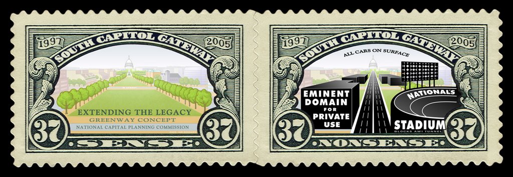
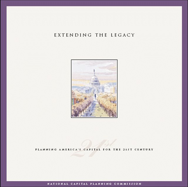
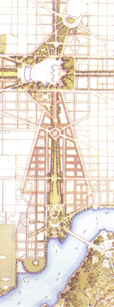
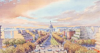 Illustration from N.C.P.C.'s 1997 "Extending the Legacy"
In the 1990s, the National Capital Planning Commission began exploring ideas for long term planning.
A 1993 article in
The Washington Post listed the basic ideas of NCPC's long term thinking to expand upon the city's various axis and focal points- e.g. the West and East Capitol axis respectively with the Lincoln Memorial and R.F.K. Stadium -- with attention focused on the axis of South Capitol Street that would be lined by new buildings replacing most or all of the existing buildings, most of which are industrial buildings, and a good amount of open parking lots, one block of 34 residential dwellings to the west between O and P Streets SW, and the one building with by far the best architecture of anything along South Capitol Street south of the SW/SE Freeway, located at the northeast corner of the inetrsection with M Street SE:
St. Vincent de Paul Roman Catholic Church.
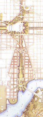
Currently a 6 lane surface street with a 4 lane underpass beneath its crossing with M Street, all within a 130 foot building line to building line right of way, South Capitol Street is similar to many other D.C. streets. Its axis though has potential given its potential vista from Capitol Hill to the Anacostia River. And the buildings along it with but one exception are not architectually significent, and which would be reletively uncontroversial to demolish. Hence, NCPC's vision for South Capitol Street was to redevelop it with a significently wider space between its flanking building lines for a new open landscaped green space: in short, the South Capitol axis would be reborn with what we would otherwise call a South Capitol Mall, or, taking and adopting the same of the South Capitol Street Bridge's official name as the
South Capitol Frederick Douglass Mall.Although N.C.P.C. apparantly never gave this Mall a name, it's the concept championed by N.C.P.C.'s 1997 publication,
"Extending the Legacy: Planning America's Capital for the 21st Century", with its numerious renderings of the future "Mall" along South Capitol, including that on its cover.

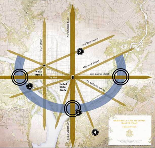
This "legacy" that was to be extended was that of Pierre L'Enfant and of the 4 architects of what is better known as the McMillan Commission plan. L'Enfant established the street grid with its grand west capitol axis National Mall to the Washington Monument The McMillan Commission plan extended this west Mall further to create the Lincoln Memorial west via new landfill. It also significantly reconciled the idea of urban railroads with this L'Enfant/McMillan classicism, by replacing the central north-south railroad link that went across the west Mall as an open cut, with an all new railroad tunnel beneath 1st Street NE/SE. It would further blend this utilitarianism and classicism magnificently with the Beaux Arts Union Station with its curved segment of Massachusetts Avenue NE
This legacy extension would have followed that of the creation of the western extension of the west Mall with its Reflecting Pool and Lincoln Memorial.
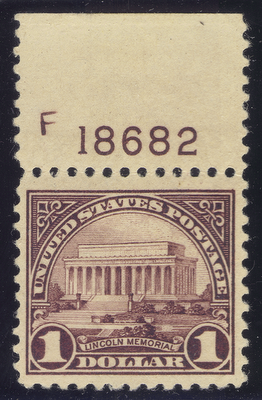
It was celebrated by the U.S. Post Office release of a $1 stamp featuring the Lincoln Memorial on February 12, 1923. (scott 571)
The next time the U.S.P.S. released a stamp that illustrated some portion of the west Mall that comes to mind is a 37 cent "commemorative" stamp for Washington, D.C. on September 23, 2003. (scott 3813) It has a diamond orientation -- mimicking that of D.C. featuring a plan view (overhead) portion of the L'Enfant street grid, flanked by isometric photographs of the Washington Monument and a row of charming late 1800s townhouses.
http://www.usps.com/communications/news/stamps/2003/sr03_048.txt

Background and details on the stamp:
The District of Columbia stamp is shaped like a diamond, as was the original 100 square mile tract of land chosen to be the permanent site of the nation's capital.
Early in U.S. history, different cities took turns serving as the U.S. capital. Then, in 1790, the U.S. Congress authorized the establishment of a permanent capital on federal land. That land would become the District of Columbia (for Christopher Columbus). President George Washington selected the exact site in the District where the capital city would be built (the city would eventually bear his name). The land for the District was ceded to the United States by Maryland and Virginia; about a third of that land was returned to Virginia in the mid-1800s, and the diamond shape was no more. Today the District encompasses almost 69 square miles.
Designed by Greg Berger, the District of Columbia stamp design features in its top quadrant a detail from a plan of Washington developed by Pierre Charles L'Enfant in 1791. This French-born engineer and architect was asked by President Washington to design the plan for the city. Though L'Enfant was dismissed from his job the next year, much of his plan was eventually implemented and can be seen in the wide avenues radiating from the White House ("President's House" on the plan) and the U.S. Capitol ("Congress House" on the plan). L'Enfant also envisioned the sweeping view from the Capitol westward along the National Mall - the long expanse of green visible near the center of the plan, as shown on the stamp.
The right quadrant of the stamp shows typical row houses in a Washington neighborhood. These particular houses are in the Shaw neighborhood. Shaw was designated an historic district in 1985.
Cherry blossoms fill the bottom quadrant of the stamp. In 1912 Japan presented Washington with cherry trees as a symbol of international friendship, and today more than 3,700 trees grow around the Tidal Basin near the Jefferson Memorial; in East Potomac Park; and on the Washington Monument grounds. Each spring hundreds of thousands of residents and visitors celebrate Washington's famous blooms at the annual Cherry Blossom Festival.
The left quadrant of the stamp is a view along the National Mall featuring three of the most widely recognized structures in the country: the U.S. Capitol (background), the Washington Monument (center) and the Lincoln Memorial (foreground). The red towers of the Smithsonian Institution Building, or "Castle," also can be seen just to the right of the Washington Monument.

Notably to me, is how this
L'Enfant street view is cropped.
To the left, it is cropped to truncated the National Mall to roughly its originally proposed length.
This makes sense when one realizes that this is the L'Enfant street grid and not the L'Enfant/McMillan street grid. This is apparent with magnification with its open canal and its lack of any Union Station (or any sign of any railroads, let alone grade separated highways.
To the right it is cropped by the row of charming townhouses, far enough away from the U.S. Capitol to show some of the street grid, but close enough to obscure the area of South Capitol Street where NCPC's Extending the Legacy envisioned its "Mall" for South Capitol Street.
How this stamp arrays these images appears largely symmetrical, as does the L”Enfant plan which centers its diamond not at the North Capitol Street axis, but rather to the west, with this stamp centering the diamond between 7th and 9th Streets NW/SW.
However, its presentation of an illustration of the un-extended plan surrounded by illustrations of latter additions, with the text commemorating "USA Washington District of Columbia The Nation's Capital", obscures the very South capitol Street corridor that was targeted by 3 separate official government studies that very same year this stamp was issued.
Its selection of using the original western end of the west National Mall as a line to mirror to the east could suggest the idea of not extending any legacies with extending any green ways/linear parks beyond the Lincoln Memorial shown in the photo to the stamp's left.
That stamp would have made a good means to commemorate this future National Mall extension, supplementing the existing West Mall with a South Mall.
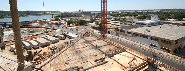
Instead, its design would subtly reflect a decision to abandon the concept of a Mall for South Capitol Street, symbolically cropping/obscuring South Capitol Street; its March 23, 2003 release would fall right between the release of the present idea of an all new stadium up against the east side of South Capitol Street
as an option in November 2002, and the U.S. National Capital Planning Commission’s abandonment its "key-note" concept from its 1990s planning. The
selection of that stadium site was publicly announced around September 22, 2004.
That location for the stadium, combined with the idea of insisting upon symmetricy sometimes, would shrink the very idea of a "monumental gateway" for South Capitol Street southwards from a 50-400 foot wide linear park extending from Virginia Avenue to the Anacostia River, a traffic circle entirely south of Potomac Avenue, squished vertically to somewhat appear as a "Mall-like park."
In light of this, obscuring the
South Capitol Street area on this stamp has an undeniable irony.
The Un Reporting 2003+The Un Reporting 1996+Why Was Not The Public Informed?