Interview of Spain's King Juan Carlos - April 1, 2013
King Juan Carlos- (KJC) Yes, Douglas Andrew, we were setting up the ancient order regarding this absolute absurdity of a baseball stadium thwarting the South Capitol Mall., essentially steering our arrogance to your blogs.


Tuesday, October 30, 2007 Pope Benedict to Hold Mass at Washington Nationals Stadium: Expect the "... King of the World!!!"
The Pope will tentatively hold Mass next April at Washington Nationals Stadium, days after its opening day. In describing this stadium's clubhouse, Jacqueline Dupree uses the term "I'm King of the World". I think that's a plausible description of someone who was there- April 17, 2008.
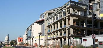
With
the Douglass Bridge viaduct now demolished, the views looking north
on
South Capitol Street easily encompass both the ballpark and the Capitol
dome. The Administration building at right is now topped out.
(10/21/07)Above photo and caption by Washington Post real estate
reporter Jacqueline Dupree
http://www.jdland.com/dc/stadium.cfm?tab=no2 Note the knife-edged clubhouse to the right.

Looking
across the roof of the under-construction admin building (or, as I call
it, the bow of the S.S. Nationals), toward South Capitol Street and
points south, including the new intersection at South Capitol and
Potomac.
I'm King of the World!!! (9/1/07) above photo and caption
Washington Post real estate reporter Jacqueline Dupree
http://www.jdland.com/dc/stadium.cfm?tab=no3
Jacqueline Dupree said it. That's the stature of someone who will be standing near that "bow" next April!
More...Labels: Pope Benedict: posted by Douglas A. Willinger @ 6:48 PM 0 comments
KJC- Yes, that reporter, 'J.D." hit the nail on the head with that caption she selected: “King of the World”.
Douglas Andrew (DA)- What a great analogy- the ‘bow of the S.S.
Nationals’ and in the context of an event filled with VIPs in April- a
clear allusion to me of the political arrogance this structure reflects,
as roughly analogous to the part of the Titanic that hit the iceberg.
KJC- Yes it was arrogant and stupid. And by design to fail as David slay Goliath- for what we Catholics all want to see; and for now the attendee list of that April 17, 2008 -- on the 218th anniversary of Benjamin Franklin's death -- event, appears to be a closely guarded secret.
But it was absolutely necessary to so monumentally display and demonstrate the degree of how the nation has been so dumbed down. And to do it with popular "entertainment", particularly as spectator sports.
Yes, you have heard the term all roads lead to Rome. That should be particularly easy to understand remembering what ancient Rome was so well known for- spectator sports viewing at stadiums aka coliseums.
Just look at the planning disaster, that we, that is organized Romish-Masonic set up as bait to see the lead person in a patriot defense of the planning of our nation's capitol from foreign influence, such as that of Rome.
Here you have a Washington, D.C. that was all set upon getting a new what would be called a "South Capitol Mall", with numerous illustrations in the U.S. N
ational Capital Planning Commission's "Extending the Legacy - Planning Americas capitol for the 21st Century"- and sharing the same term given by the appropriate Masonic bodies to the 1985-2002 term of Fred Kleinknecht.


Fred Kleinknecht's time as 'Sovereign Grand Commander is termed "Extending the Legacy"

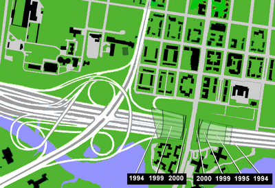
U.S.N.C.P.C.'s program featuring the un-officially named South Capitol Mall
is also called "Extending the Legacy"


 But lol and behold. It was 2003 that brought the abandonment of constructing any real version of a SCM
A, deciding to not widen the right of way- nevermind that ultimately saved only one building- the St Vincent dePaul Roman Catholic Church just north of M Street- owing to the area being envioned to have a near replacement of its buildings with newer construction. Yet it was in late 2002- the previous year- that the stadium report was released publicly; and it included the one directly alongside South Capitol Street. To even consider such an idea given the wide release of the Extending the Legacy renderings of the future SCM greenway, including its utility for facilitating an underground highway connection with the I-395 3rd Street Tunnel, suggests an unaccounted influence.
DA- A city planning that so silently abandoned the SCM, and the subsequent stadium deal approval as a reversal by the D.C. City Council in a
closed-door post mid-night special session -- and virtually unreported by the MSM and ‘muckrackings’ as Fields of Schemes Neil DeMause all suggest such an influence. Given a number of factors -- the St.Vincent dePaul Church; the measure of involvement of religious orders as the Knights of Malta with MLB and its push for that particular stadium location, and the connections of Washington, D.C. director of Sports and Entertainment, all speak volumes about how "all roads lead to Rome".

Peter Kolvenbach, S.J.
born November 30, 1928;
29th Superior General of the Jesuit Order, 'retired' 2008

Kolvenbach was in Maryland, adjacent to Washington, D.C.,
something like a day or two prior to the April 17, 2008 Papal Mass.
That pose above, which comes from Jesuit sources, appears selected to convey
that the apostate to 'extending the legacy' stadium was his idea.
JD photo
LINK-
The Telling Behavior of Neil DeMause 'Field of Schemes'
KJC- Douglas Andrew, we knew about you already from your on-line advocacy of
an appropriate freeway system for Washington, D.C., and such
for the Capital Beltway reconstruction in Alexandria Virginia- the "Alexandria Orb".
December 18, 2000
The Shrinking Washington Street Urban Deck
My Alexandria Orb Proposal
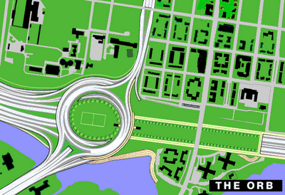

That was actually a very nice idea, even as, sadly, it pissed off a segment of the local establishment for such an idea from an apparent outsider. Alas, we were not ready to give you that victory back then, though nice shot for a millennial gateway.
But your Alexandria Orb proposal, which you filed a copyright on December 22, 1998, alerted us to you as a potentially potent advocate for positive change for as many as possible.
So was your 1997+ postings through such venues as dc.driving and misc.transport.road. And of course
that astonishing assortment of people you
collected together, challenging the current
mythos of no new freeways inside the Capital Beltway.
DA- Ah! The Capital Beltway. THE Beltway. That which we hear constantly as a sort of metaphor for the political reality.
And that which may appear to represent some sort of divine mandate to rule, a thought emanating from so many things in so many days from inside the Beltway, particularly within Washington D.C., plus the Bethesda-Chevy Chase broad corridor. Which represents certainly a vast disproprtionate level of influence of the wealthy versus the less affluent as can be seen geographically with the deletions of the inside the Beltway freeway system and the ripple effect.
KJC- Ripple effect?
DA- Yes, ripple effect. Bethesda gets to say no on the Northwest Freeway- that is the one that would have continued the eastern fork of I-270 (then I-70S) inside the Beltway paralleling Wisconsin Avenue to a cut and cover tunnel segment beneath Tenly Circle in Washington, D.C. From there it was to either continue via Glover Archibold Park, or have a split with the preceeding plus a spur easterly to the I-66 North Leg of the Inner Loop at 14th and U Streets NW.
With Bethesda and far northwest getting their 5 year moratorium on freeway planning to the west of Rock Creek Park in the 1960 transportation act, planning turned towards a North Central Freeway routed along the B&O railroad tracks- a plan that we both know was botched deliberately.
KLC- And which hardly anyone ever heard or saw, because we had all jammed the airwaves with the simplistic communust propoganda like sloganeering- you know a short catchy phrase that serves a multiple of purposes like how one sees and thinks, and can serve as distraction from initiating indeendent thought processes. Like "no white mans' roads through black man's homes"... and you are the nine year old asking about that and wondering about that wide power line right of way corridor questioning the popular slogan as representing popular intellectual laziness.
DA- And thus being able to see the environmentalist movement, namely its mainstream version, e.g. that which can talk about conservation but not challenge mercantilism, such as that against Hemp. Your situation with the failure to complete the Washington, D.C. freeway system is a classic example of wealthier areas getting off of their area's burden by kicking the can down the road. The Princeton, New Jersey corridor's stopping of I-95 in western New Jersey, by denying this connection to I-287 to divert traffic around the greater NYC area, places extra traffic upon the segment of I-95 that passes through NYC- the Cross Bronx Expressway. Accordingly this is justified for discouraging some rural development, even as disproportionately less attention is given to environmentally mitigating the existing I-95 Cross Bronx Expressway. A great many more people live in close confines to the Cross Bronx Expressway than to western new Jeersey's now missing I-95 segment.
KJC- Whoa! That's getting into environmental injustice issues, matters which make it more obvious that authority was way more centralized then popularly perceived!
So that is why this set up is intentional to show just how stupid things have come.
Imagine something like the McMillan Plan being shown to the public, and
after thousands of people saw the model, it gets squashed, with no
visible public discussion nor controversy.
DA- Indeed, take a look closely to the sequencing within the planning.
The 1995 through 1997 N.C.P.C. documents show numerous illustration of the
future ‘Mall’, which is the single most significant future addition here
proposed in ‘Extending the Legacy’.
“With the expressway removed, South Capitol Street can become another Pennsylvania Avenue with an enticing mix of shops, housing and museums”
“This dramatic site where South Capitol Street meets the water is ideal for a major civic building, such as the Supreme Court”
However this is without any mentioning of the term “Mall” nor even greenway, nor linear park.
Instead the terminology is boulevard and gateway. These are terms all
the more vague and less useful for informing people, but more useful for
confusing them, as any such plan would have ‘boulevard’[s] as part of a
gateway, though not necessarily accompanied by any sort of broad linear
park, as that shown on the very cover of Extending the Legacy Planning
America’s Capital for the 21st Century.
KJC- Apparently, the
whole South Capitol Mall concept was developed through U.S. N.C.P.C. prior
to the decision from top of the political pyramid to kill it, given the
numerous illustrations but the utter lack of appropriately descriptive
text.
DA- Indeed, at a public gathering in Washington, D.C. in 1997, internet writer Richard Layman told me that Extending the Legacy
had originally planned to extend further, namely in re-crafting the
enormous open rail yards and railroad corridors extending northward from
the rear side of Washington, D.C.’s Union Station, covering and perhaps
even lowering these corridors.
Under this idea, the railroad
corridors would be reconstructed with vast new linear parks built atop,
better connecting the area locally, and even regionally by expanding
this railroad- as well as the idea un-mentioned by Layman of including a
new set of cut and cover highway tunnels providing D.C. its now missing
set of northern and eastern express highway routes.
The decision to kill the South Capitol Mall apparently occurred by the
time of the publication of the Extending the Legacy, given the lacking
terminology.
The decision to kill the idea addressing the railroad corridors was
apparently made earlier, given its utter exclusion from Extending the
Legacy.
That these decisions were apparently made at different times – IOW why
was not the ‘South Capitol Mall’ deleted from the illustrations as was
the ‘Metropolitan Branch [the name of the railroad] Mall’ – may suggest something about the political hierarchy’s different levels.
KJC- Yes! Just take a look at the family that King Juan Carlos is a descendant- the family Farnese.
The Farnese family helped create the Jesuit Order, with the name
Farnese appearing on Ignatius Loyola's tomb and the front of the Order's
Mother Church in Lazio, Rome, the Gesu.
They also constructed
what's been called the original Pentagon, located on a hill with a
skinny street and the green-space instead clustered directly around this
building.


 http://continuingcounterreformation.blogspot.com/2010/04/dcs-monumential-indicator.html
Note
the treatment of the corridor extending down the hill from Villa
Farnese of a narrow street (in what appears in the lower photo to be
triangular in shape).
Naturally
the following from the UK based
The Un-Hived Mind caught y
ou eye:
I have just concluded a trip to the
Villa Farnese which was the ORIGINAL 'Pentagon' in Caprarola. What is amazing is that they arrogantly and proudly admit to controlling Washington D.C. and that the building was the original prototype. It was created as a secret and hidden meeting place for Cardinals to command their legions in Germany to counter the reformation and to plan the 30 years war. In its map room, we you can visit as a tourist, there are 5 maps of the United States dated to before the American Revolution 1600s. One of these includes a future capital where washington is today.
THESE PEOPLE DESIGNED AMERICA!
THEY LAID OUT WHERE EVERYTHING WOULD BE BEFORE IT CAME!
.....Then, the brainwashed tour guide told us that: "Oh my, it's a very strange coincidence that the future capital would be positioned there 'between Maryland and Virginia' and that the Pentagon is on the map too. The Farnese might have been psychic. After all they were popes"
Psychic, MY ASS --- They built Washington! and its even got the Washington Monument on the same map!
check this out; Washington D.C. is between VIRGIN (ia) & MARY (land)
These Jesuits admit to EVERYTHING! We are the stupid ones, in that we just don't care. They get away with everything. Look at the inscription on Ignatius Loyola's tomb: What does it read: ' CARDINAL ALEXANDER F A R N E S E '
http://en.wikipedia.org/wiki/Alessandro_Farnese_%28cardinal%29 http://en.wikipedia.org/wiki/Villa_Farnese#History http://en.wikipedia.org/wiki/Pope_Paul_III http://en.wikipedia.org/wiki/The_Pentagon
ANYBODY WHO THINKS THE JESUITS DON'T CONTROL WASHINGTON ARE SIMPLY RETARDED PERIOD!!!
THE FARNESE RAN THE JESUIT ORDER AND STILL DO TODAY!
Posted by
Douglas Andrew Willinger
at
10:14 PM
A Crafted Controversy- the scuttling of JFK's B&O North Central Freeway
http://wwwtripwithinthebeltway.blogspot.com/2012/01/crafted-controversy-scuttling-of-jfks-b.html
Washington, D.C. Freeway Planning Hegelian Dialectic
http://wwwtripwithinthebeltway.blogspot.com/2010/05/1960s-washington-dc-freeway-planning.html


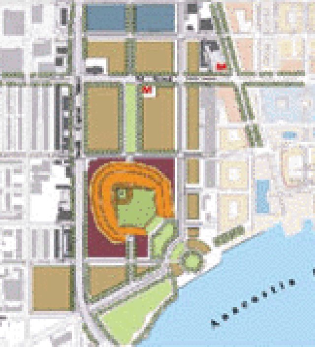


 U.S.N.C.P.C.'s program featuring the un-officially named South Capitol Mall


 JD photo