Extend a covered – tunnel – SE Freeway to RFK, topped by a new monumental terraced waterfront promenade and surface road
Between the 11th Street Bridges and Barney Circle, the westbound traffic capacity of the SE Freeway is underutilized while its eastbound capacity is bottlenecked by the SE Freeway’s truncation at Barney Circle and its consequential diversion of traffic across the Pennsylvania Avenue/Sousa Bridge to the incomplete interchange with the Anacostia Freeway, which runs along the continuous length of this south or east side of the Anacostia River, reducing local access to the adjoining neighborhoods, such as Hillcrest.
Failing to extend the SE Freeway to RFK Stadium diverts traffic from the truncated SE Freeway on the west side of the Anacostia, to a bridge to the east side of the Anacostia River places a disproportionate proportion of the traffic burden on the neighborhoods It does protect local accessibility along the waterfront area of the Anacostia west shore in the area around Congressional Cemetery, part of which is now lined by a surface RR, but it reduces the SE Freeway’s utility, while doing nothing to remove the local barrier effect of the existing SE Freeway segment to Barney Circle’s west, nor those of the fully continuous I-295/DC Route 295 Anacostia Freeway on the other side of the river.
Best serving the principle of environmental justice would be to protect and promote these concerns broadly and fairly, with equivalent environmental mitigation for neighborhoods on both side of the Anacostia River translates to both reconstructing existing freeway segments with improved designs that feature greater operation ability, safety and environmental mitigation, particularly tunnels to contain noise, air pollution and run-off such as brake dust, with such standards applied to extending the SE Freeway to RFK Stadium.

RX:
West of the Anacostia River
Extend a tunneled SE Freeway to RFK stadium/East Capitol Street, doing this relatively good economy of scale via taking advantage of the topography to avoid the significant expense of excavation for much of the route, and with significant local benefit in improving RFK area accessibility, with a new highway cover that would essentially serves as an western and an eastern extension of the current island of Barney Circle.
The existing SE Freeway could be made into a tunnel with its full capacity with building such a cover west to the point where the ramps to and from RFK Stadium ascend to the 11th Street Bridges (with these ramp connections being retained in what ever redesign that may occur with the 11th Street Bridges).
So could the freeway extension through and to the east of the Barney Circle underpasses for the ¼ mile or so it would pass paralleling the boundary of Congressional Cemetery and the RR, with a full cover featuring a terrace to the waterfront. It could be so designed with a cover to skirt around the southeastern edge of Congressional Cemetery (or it could conceivable cut beneath its edge); and it would require excavation only for the northern portion if it is to turn a bit away from the waterfront to instead run more through the existing parking lot areas, and covered to serve the local environment and accessibility.
Illustration: SE Freeway topographical cross section.
Any project to reconstruct the 11th Street Bridge must maintains ramp connections from its north end to and from RFK Stadium. Eliminating these ramp connections would deny a direct I-295 connection, diverting such traffic further east to the East Capitol Street Bridge, or up a South Capitol Street that lacks a ramp connection to the SW Freeway, hence forcing traffic instead through residential surface streets.
Reconstruct SW/SE Freeway underground, with project to include completely depressing and covering the entire SW Freeway to South Capitol Street, and the SE Freeway from there east to 7th Street SE.
Address the SE Freeway west of the 11th Street Bridges and the SW Freeway, even though these segments will be considerable more expensive per lane mile, as they will carry relatively great amounts of traffic over relatively short distances. Both will be more expensive to tunnelize, because rather than simply building a cover over an existing highway or its extension along a ridge with little or no major excavation, this involving removing a viaduct and building an all new cut and cover, perhaps with some drilled tunneling, but definitely requiring some cut and cover ultimately for transitions to the surface. Also, because portions of this freeway run along or cross over a generally paralleling RR, this reconstruction must accommodate this RR’s future. With the requirements of minimizing the construction project footprint and of maintaining SW/SE Freeway traffic flow throughout the construction itself, the new tunnel roadways would have to be constructed to take advantage of the greatest existing open spaces within the 70 or 80 feet immediately along the SW Freeway’s southern edge.
This mostly or entirely avoids displacing any dwellings to the east of 7th Street SW, just south of the headquarters of the U.S. Departments of Transportation and of Housing and Urban Development, and confines such displacement to a row of 28 luxury townhouses built in 1999 a mere 16 ½ feet from the SW Freeway retaining wall.
Further west the construction would temporarily take the northern edge of the Banneker Knoll, which would be subsequently restored. This Banneker knoll area is particularly crucial regarding any ideas presented for helping to better locally connect SW, and the National Mall and the Jefferson Memorial with the Hanes Point Park, with these areas being separated to no insignificant degree by the 14th Street and I-395 roadways. It is important because it provides the space for reconstructing the SW Freeway in a truly comprehensive manner: not only burying it with superior safety and capacity operation ability as the newly staged parallel roadway would permit additional lanes to the I-395 Center Leg (3rd Street Tunnel), but also extending the under grounding further west to reconnect the area around the Jefferson Memorial, eliminating the massive elevated roadways that now obstruct the site lines such as that along G Street SW, while relocating the highway and where it would emerge to meet its spans crossing the Potomac River a bit further away to the south, perhaps to a new traffic circle centered on 14th Street. This would be done as part of a project to remove and replace the existing 14th Street and I-395 Bridges, and the existing RR, including perhaps a new tunnel for WMATA. Current planning for that area irresponsibly places buildings too close to the existing highway.
Any planning for a building atop this right of way must accommodate this to minimize wasteful demolition which would far exceed that of the 28 EYI “Capital Square” townhouses along the SW Freeway’s retaining wall.
East of the Anacostia River
Adopt the concept of reconstructing the Anacostia Freeway with design improvements including depressing and fully covering over significant segments, for maximizing environmental mitigation, with design capacity for additional and future capacity with better economy of scale, with the design and the placement of the submerged retaining walls.
Include continuous merge lanes and at least one additional lane per direction in the mainline, plus the space for an immediately parallel depressed/coverable roadway to provide the flexibility for the future (such as a cross Potomac Tunnel to the Shirley Highway, Virginia 110 and a Route 1 bypass via Potomac Yards). Design this to serve the parallel RR and its future, including that as an already planned location of a Light Rail Line (LRT). Designing submerged retaining walls to support a lid converting depressed highway into a full tunnel, and to serve a parallel underground transit-way are duel principles embodied by Cincinnati, Ohio’s Washington Way reconstruction project.
Be sure that any design for portions of the Anacostia Freeway to be underground, either as part of the initial project, or staged with a below grade highway with retaining walls designed to support a lid as a tunnel roof.
These concepts can be applied to portions of the Anacostia Freeway northeast past Pennsylvania Avenue, particularly the area around East Capitol Street with an idea of improving access locally and regionally, with a covered interchange between the Anacostia Freeway and East Capitol Street, and with extending the reconstruction to the interchange with Maryland Route 50 and the Baltimore-Washington Parkway, while extending the design of the monumental core parklands to the east.
And On Both Sides of the Anacostia River:
Build an all new bridge across the Anacostia River connecting Massachusetts Avenue SE. Build this bridge primarily or exclusively as a local traffic bridge without connections to the freeway extension east of Barney Circle to RFK (in part due to the close spacing between the interchanges with East Capitol Street and Pennsylvania Avenue. This would be compatible with the officially envisioned redevelopment of the D.C. General site, and with the southern portion of the East Leg covered. But it would have been blocked by the Barney Circle Connector Bridge that was formally proposed in 1983 and cancelled in 1996.
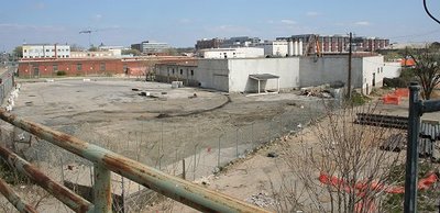 Looking north into the stadium footprint from South Capitol Street and Potomac Avenue, the southwestern edge of the site, just before demolition began. (04/06)
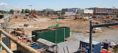 The same location, six weeks later (May 20). Much of the demolition is finished. (And the Capitol Dome is more visible now, too.) (05/06)










 RX:
RX: 


